Find the best place to live in England, Scotland or Wales
Choosing the best place to live is not easy. There are so many different things to think about: price of housing, jobs, broadband speed, clean air, level of crime, schools. Luckily in the UK there are many resources that can help you find detailed information so you can choose the best city, town or area.
However, if you are not sure where to even start, here is list of the 36 English, Scottish and Welsh cities and towns over 180,000 people, ordered by size. This overview of British cities and their key statistics might help you make a decision about where to live in the UK.
Britain’s biggest cities all have their own character. Some are very old, some new. All are diverse and interesting and have become home to communities from around the world. Some cities are known for their beauty or architecture, others for their culture or sports focus.
- Comparing the data listed for each city (population density, median rental cost, area crime rate and average distance to the nearest park), Stoke-on-Trent emerges as the best large city because it is in the only place that is in the top 5 of the list for two of the criteria (low crime rate and short distance to nearest park). It is also within the top 10 cheapest cities for renting and has one of the top 20 lowest population densities.
- Peterborough is in the top 5 for population density, in the top 10 for low crime rate and in the top 20 for short distance to parks and lowest rental cost. Also scoring well using this data is Derby: in the top 10 for lowest average distance to the nearest park and lowest rents, and in the top 20 for low crime and low population density.
- Milton Keynes offers a low population density (top 5), low crime rate (top 10) and short distance to the nearest park (top 20), but rents are relatively high. Another option is Brighton, which is among the top 5 lowest crime rates and also in the top 20 for closeness to nearest park and low population density. Other cities scoring well on at least 3 parameters include Swindon, Bradford and Bolton.
- If rental price and safety are your most important factors, Hull and Aberdeen have the lowest crime rates within the top 5 cheapest cities. Consider also Swansea or Plymouth: both are in the top 10 cities with the lowest rents and crime rates, plus Swansea has a very low population density. As a bonus, these four cities also have sandy beaches nearby. Sadly there’s no guarantee of great weather!
Top 20 biggest British cities by size
London
Population: 9.0 million
Population density (people/km²): 5,000
Cost of rent: £2,500
Crime rate: 85
Average distance to nearest park: 291 metres
Local authority: Split into 33 boroughs, overseen by the Greater London Authority
London was founded by the Romans as a port city over 2,000 year ago. Modern London is actually centred on 2 old cities: the City of London (famous as a centre of global finance) and the City of Westminster, which lies to the west and is where the government and parliament is based. Many old towns and villages also now lie within modern London’s boundaries, which means each area has a different character and identity. London has been one of the world’s most important cities for a very long time. For nearly 100 years from 1831 it was the world’s largest city too. Its wealth and influence comes from finance, insurance, media, technology and the arts.
Birmingham
Region: West Midlands
Population: 1.2 million
Population density (people/km²): 3,900
Cost of rent: £900
Crime rate: 111
Average distance to nearest park: 357 metres
Local authority: Birmingham City Council
In medieval times, Birmingham was a small town. It grew rapidly during the 1700s and became famous because of it was home to thousands of of skilled craftsmen as well as inventors, and scientific and academic thinkers. Its position in the centre of England made it a transport hub and famously, there are more miles of canals than Venice – although they are much less obvious. The city was heavily bombed in World War 2, then rebuilt in the 1960s and 70s. Today the economy is mostly service-based. Birmingham has a very active arts scene and has become famous as the location for the Peaky Blinders tv series.
Glasgow
Region: central Scotland
Population: 620,000
Population density (people/km²): 3,600
Cost of rent: £800
Crime rate: 130*
Average distance to nearest park: 320 metres
Local authority: Glasgow City Council
Glasgow (Glaschu in Scottish Gaelic) started as a small fishing village, but it grew into Scotland’s most important port with the trans-Atlantic trade in slaves, sugar, cotton and tobacco in the 1700s and 1800s. It was once also famous for industry – by the end of the 1800s it produced half of Britain’s ships and a quarter of the world’s railway engines. The city has many examples of stunning architecture and has inspired artists, inventors and novelists. During the 20th century, it suffered a severe decline, followed by redevelopment. It now attracts thousands of tourists every year to its cultural sites.
Liverpool
Region: Merseyside
Population: 590,000
Population density (people/km²): 4,000
Cost of rent: £725
Crime rate: 101
Average distance to nearest park: 278 metres
Local authority: Liverpool City Council
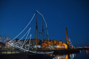
Liverpool (pictured) is on the east side of the Mersey river and is one of the UK’s largest ports. However, in the 1500s, Liverpool was a small village of about 500 people – it only grew because of ships sailing to and from the Americas. A commercial dock was built in 1715 and the trade of slaves, sugar, tobacco and rum helped to make the city very wealthy, with many examples of impressive architecture. This trade has now finished, but made Liverpool very diverse, with people settling from around the world. The shipbuilding industry and docks declined in the 1900s, but the city is now regenerating.
Bristol
Region: south west England
Population: 580,000
Population density (people/km²): 4,000
Cost of rent: £1,200
Crime rate: 74
Average distance to nearest park: 278 metres
Local authority: Bristol City Council
Bristol was founded in about the year 1000CE. It has an important position on the coast and quickly became an important port for trade with Ireland. In the 1700s, it was a central point for the slave trade to the Americas, as well as products like sugar, cotton and rum. The port became less important during the 1800s, but other industries helped to keep the city wealthy and it has many examples of fine architecture. By 1901 there were 330,000 people. It suffered from heavy bombing in World War 2, with modern buildings often replacing the damaged ones. It is now an important centre for aerospace, electronics and media.
Manchester
Region: Greater Manchester
Population: 570,000
Population density (people/km²): 4,300
Cost of rent: £1,100
Crime rate: 113
Average distance to nearest park: 313 metres
Local authority: Manchester City Council
Manchester is famous for its football teams, impressive architecture and working-class history. The city dates back over 2,000 years to Roman times. In 1700 it was still a small town of 10,000 people, but grew to a city of 300,000 by 1850 because of growth in textile manufacturing (especially cotton cloth), which made it the world’s first industrial city. Industry has now declined, and instead it is now important for music, media, science and engineering. There was heavy bombing in World War 2; Manchester was extensively redeveloped in the 1960s.
Sheffield
Region: South Yorkshire
Population: 560,000
Population density (people/km²): 1,500
Cost of rent: £737
Crime rate: 97
Average distance to nearest park: 317 metres
Local authority: Sheffield City Council
Sheffield lies at the edge of the beautiful Peak District – as well as many steep hills, it has more than 250 parks, woodlands and gardens. It is well known for sport, including snooker, ice hockey and the world’s oldest football club,. There is evidence that Sheffield has been inhabited for over 12,000 years. Until recently, Sheffield was famous for knives and cutlery, a trade that dated back to the 1300s. Steelmaking helped it to grow further, and between 1801 and 1901 the population grew from 60,000 to 451,000. The city was heavily bombed in World War 2, then a hurricane in 1962 damaged 70% of the city’s houses, leading to redevelopment. Steelmaking and cutlery are no longer a focus, with the economy now more service-based.
Leeds
Region: West Yorkshire
Population: 520,000
Population density (people/km²): 1,500
Cost of rent: £875
Crime rate: 114
Average distance to nearest park: 341 metres
Local authority: Leeds City Council
Leeds is a market town over 1,000 years old with clear influences of settlement in Viking times in the names of the streets (Kirkgate, for example). It grew during the 1600s and 1700s because of the wool trade – in the 1800s this led to the development of textile mills, factories and impressive architecture in the city centre. Leeds declined during the 1900s, but investment has transformed it into a vibrant centre for the media, finance and insurance industries. Leeds is located close to some of the most stunning landscapes in England, such as the Yorkshire Dales National Park and the Pennine hills.
Edinburgh
Region: central Scotland
Population: 490,000
Population density (people/km²): 2,000
Cost of rent: £1,250
Crime rate: 86*
Average distance to nearest park: 307 metres
Local authority: City of Edinburgh Council
Edinburgh (pronounced ‘eddin-bruh’) is the elegant capital city of Scotland and home to many of its most important government, royal and cultural buildings. The city is dominated by Edinburgh Castle, built in the the 1200s, and Arthur’s Seat, an ancient volcano. Edinburgh is said to be the birthplace of the skyscraper – even in the 1700s there were structures up to 11 stories high. During the 1800s, the main industries were printing, brewing and distilling. These have mostly gone, replaced by financial and business services. Edinburgh (Dùn Èideann in Scottish Gaelic) is famous for the world’s largest annual arts festival in August and also its Hogmanay celebrations on New Year’s Eve.
Leicester
Region: Leicestershire
Population: 420,000
Population density (people/km²): 4,200
Cost of rent: £750
Crime rate: 83
Average distance to nearest park: 299 metres
Local authority: Leicester City Council
Leicester (pronounced ‘less-ster’) is one of Britain’s oldest cities, at least 2,000 years old. It was once a Roman fort and has played an important part in British history over hundreds of years. The population of 68,000 in 1861 grew to over 200,000 by 1901 because of textile, footwear and engineering factories, although these have now been replaced by banking, insurance and service industries. The population further expanded after World War 2 with the building of large housing estates. Leicester is one of Britain’s most multicultural cities and about 70 languages are spoken there.
Coventry
Region: Warwickshire
Population: 390,000
Population density (people/km²): 3,200
Cost of rent: £767
Crime rate: 111
Average distance to nearest park: 344 metres
Local authority: Coventry City Council
Coventry was once a walled city that became rich on the wool and textile trade in the 1300s, although by the 1800s and 1900s it was industry that made it rich – especially the motor industry and bicycle industry (in the 1890s nearly 40,000 people worked in the bicycle industry alone). Before World War 2, Coventry was called ‘the best preserved medieval city in Europe’. However, in November 1940, a bombing attack by Germany led to a firestorm that destroyed most of the city centre. The ruined cathedral was left as a reminder, but the rest of the city was rebuilt in modernist style. In 2021, it was named UK City of Culture and it is the building the world’s first Urban-Air Port for drones.
Bradford
Region: West Yorkshire
Population: 360,000
Population density (people/km²): 1,400
Cost of rent: £575
Crime rate: 114
Average distance to nearest park: 309 metres
Local authority: Bradford Metropolitan District Council
For most of history, Bradford was a small market town. In 1801, it had a population of 6,000 people. However, it grew because of coal mining and the production of iron and its world-famous worsted woollen cloth (it was once known as the ‘wool capital of the world’). Textile mills were built across the city, although when the industry started to decline after the 1920s, it hit Bradford hard and there was a lot of unemployment. Today modern technologies, including chemicals, engineering and manufacturing are some of the main focuses of Bradford. It is a UNESCO City of Film, and the National Cinematography collection can be found here.
Cardiff
Region: south west Wales
Population: 360,000
Population density (people/km²): 2,500
Cost of rent: £863
Crime rate: 74
Average distance to nearest park: 298 metres
Local authority: Cardiff Council/Cyngor Caerdydd
People have been living in the Cardiff area for nearly 6,000 years. Its coastal location was important for defence and trade. The Romans built a fort in 75CE, later King William 1 built a castle – which is still there today. However, it was a small town until the 1830 when its new docks and train service made it the main port for coal from the Welsh valleys. There was huge expansion. For example, in 1801, there were 1,900 people. By 1901, there were 164,000 and by 1951 there were 243,000. Cardiff (or Caerdydd in Welsh) is the capital of Wales and the site of the Senedd (Welsh Parliament).
Nottingham
Region: Nottinghamshire
Population: 320,000
Population density (people/km²): 4,100
Cost of rent: £983
Crime rate: 77
Average distance to nearest park: 285 metres
Local authority: Nottingham City Council
Nottingham dates back to the time of the Anglo-Saxons in about 600CE. After the Normans invaded England in 1066, they build a castle in Nottingham, later the home of the Sheriff of Nottingham from the famous story of Robin Hood. During the 1800s, Nottingham became an important centre for textiles, and lace in particular. This industry has now gone and today, some of the main industries are science, sport, media and finance. One surprising aspect of the city is that there is a network of ancient manmade caves underneath. Over 4,000 homes in the city use district heating, which is very unusual in Britain.
Newcastle upon Tyne
Region: Northumberland
Population: 290,000
Population density (people/km²): 2,600
Cost of rent: £750
Crime rate: 88
Average distance to nearest park: 260 metres
Local authority: Newcastle City Council
Although often known just as ‘Newcastle’, the full name is used to prevent confusion with the town of Newcastle-under-Lyme in Staffordshire. Newcastle started as a Roman port and it was as a port that it grew into a city, especially because of a monopoly on trading the region’s coal that started in 1530. In the 1800s and 1900s it became famous for printing, shipbuilding and glassmaking. It was the centre of several modern innovations and in 1879 it had the world’s first street lit by electric bulbs. Newcastle is regularly listed as Britain’s friendliest city.
Hull (Kingston upon Hull)
Region: East Yorkshire
Population: 290,000
Population density (people/km²): 3,700
Cost of rent: £525
Crime rate: 93
Average distance to nearest park: 403 metres
Local authority: Hull City Council
Hull’s full name is Kingston upon Hull, but it is almost always called just Hull, which is actually the name of the river. As a large port, Hull got its wealth through the trade of wool and woollen cloth with cities across the Baltic sea. It was particularly rich between 1500-1700; a few fine buildings remain from that time. After that, international trade, whaling and fishing were important, creating a diverse city with a large amount of art and culture. It was damaged in World War 2, after which most of the city centre was rebuilt.
Stoke-on-Trent
Region: Staffordshire
Population: 280,000
Population density (people/km²): 2,600
Cost of rent: £607
Crime rate: 60
Average distance to nearest park: 211 metres
Local authority: City of Stoke-on-Trent Council
Stoke-on-Trent (often just known as Stoke) is a city that was created in 1910 by merging 6 neighbouring towns that lie in a line along the A50 road. Stoke lies in an area rich in coal, iron ore and clay and has the nickname ‘the Potteries’ because it was once the centre of the British pottery industry. Famous brands like Royal Doulton, Spode and Wedgwood were all based here. You can still see many of the huge ‘bottle kilns’ that were used to fire the pottery. Steel was another important industry, but today the coal and steel have gone, while there are only a few pottery producers left. Today, some of the biggest employers are call centres, service centres and distribution centres.
Southampton
Region: Hampshire
Population: 270,000
Population density (people/km²): 4,900
Cost of rent: £871
Crime rate: 77
Average distance to nearest park: 347 metres
Local authority: Southampton City Council
Located on the south coast, Southampton started as a small Stone Age settlement. After the Norman invasion of 1066, it became a major port transporting products to and from France. It then developed into a walled medieval city. Trade and shipbuilding brought wealth and the city was famed for its elegant high street. However, much of the city was destroyed by bombing in World War 2 and it was rebuilt in a modern style. Today the shipyards have closed, but it is still an important port for cruise ships and freight.
Plymouth
Region: Devon
Population: 270,000
Population density (people/km²): 3,200
Cost of rent: £700
Crime rate: 54
Average distance to nearest park: 354 metres
Local authority: Plymouth City Council
Plymouth (pronounced ‘plim-uth’) lies on the south coast that has a long history as a port and Naval base. Shipping and defence are still big employers in the city, but it is also important for media and science. The city was heavily bombed in World War 2, but was rebuilt to a new plan in a modernist style. Its weather is milder than much of the rest of the UK and many exotic trees are able to grow there, including palms and yuccas.
Derby
Region: Derbyshire
Population: 260,000
Population density (people/km²): 3,200
Cost of rent: £650
Crime rate: 76
Average distance to nearest park: 311 metres
Local authority: Derby City Council
Pronounced ‘darbee’, Derby is a city dating back to the Romans. Later it became one of the five most important Viking towns. Derby was also one of the first Industrial Revolution towns: in 1717, a silk mill was built using water power from the River Derwent. Later factories included luxury porcelain manufacturer Royal Crown Derby and carmaker Rolls Royce. The city is still an important place for the aerospace, car and rail industries. Derby has the largest deaf community in the UK outside London.

More British cities above 180,000 people
Reading
Region: Berkshire
Population: 260,000
Population density (people/km²): 3,800
Cost of rent: £1,000
Crime rate: 68
Average distance to nearest park: 378 metres
Local authority: Reading Borough Council
Reading (pronounced ‘redding’) has a history dating back to about 700CE. Its name comes from the Anglo-Saxon for ‘Reada’s people’. In 1121, King Henry I founded an abbey and Reading became a place of pilgrimage. The abbey was destroyed by King Henry VIII. By 1800 it was a town of 9,400 and by 1900 it had grown to 59,000 through manufacturing and brewing. Over the next 100 years its growth was mostly because it acted as a commuter town for London. In the 1980s, the Lower Earley housing area was the largest private development in Europe (about 30,000 people).
Wolverhampton
Region: West Midlands
Population: 250,000
Population density (people/km²):3,500
Cost of rent: £625
Crime rate: 111
Average distance to nearest park: 351 metres
Local authority: City of Wolverhampton Council
Wolverhampton was founded in 985CE and was a small market town. By the 1300s, it was an important wool trading centre. It is surrounded by iron and coal deposits, so gradually coal mining, steelwork, steel jewellery, lock-making and bicycle-making became more important. By the 1800s, it was an industrial city and the population reached 95,000 by 1901. Heavy industry declined in the 20th century, while an excess of poor quality housing meant the city centre was redeveloped and modernised. The Ministry of Housing, Communities and Local Government will be based in Wolverhampton from 2025.
Brighton
Region: West Sussex
Population: 250,000
Population density (people/km²): 3,100
Cost of rent: £1,400
Crime rate: 65
Average distance to nearest park: 321 metres
Local authority: Brighton & Hove City Council
Brighton is a vibrant seaside city that is famous for its diverse, creative community and its tolerance. The city hosts many annual festivals, including Brighton Arts Festival, Brighton Pride and Disability Pride. It is also well known for its attractive architecture, much of it from the 1700s and 1800s when it developed from a fishing port into a popular resort, a favourite of King George IV. Brighton is now linked to the neighbouring town of Hove; the official name of the city is Brighton & Hove.
Northampton
Region: Northamptonshire
Population: 230,000
Population density (people/km²): 2,600
Cost of rent: £800
Crime rate: 81
Average distance to nearest park: 355 metres
Local authority: West Northamptonshire Council
Northampton is at least 1,000 years old. In Norman times (about 1100), it was surrounded by stone walls and had a royal castle. Much of the town was destroyed by the civil war and a fire in the 1600s – St Peter’s church is one of the few Norman buildings that remain. In the 1800s, the town became wealthy because of its shoe and leather factories, but the population remained relatively small at about 90,000, even in 1930. Its real growth came after the 1960s when it became a commuter town for London. It is surrounded by excellent farming land and many people work in the food industry, with the brewer Carlsberg among the companies based in Northampton.
Portsmouth
Region: Hampshire
Population: 230,000
Population density (people/km²): 5,100
Cost of rent: £950
Crime rate: 77
Average distance to nearest park: 389 metres
Local authority: Portsmouth City Council
It is not obvious, but Portsmouth is actually on a small island that lies just off the south coast of Britain. Founded by the Romans, Portsmouth has been an important Naval base since the time of King John in 1200, while the threat of invasion from France meant that it was heavily fortified. In 1803, it was the site of the world’s first mass production machines. Heavy bombing in World War 2 and modern redevelopment have changed the look of the city. Today it is Britain’s second-busiest passenger port, while 10% of people work in defence or shipbuilding. It is famous for an annual kite festival.
Luton
Region: Bedfordshire
Population: 220,000
Population density (people/km²): 4,600
Cost of rent: £825
Crime rate: 72
Average distance to nearest park: 354 metres
Local authority: Luton Council
Luton has a history stretching back to about 600CE. The town was once famous for hat-making. In the 1800s there were over 500 workshops making hats plaited from wheat straw grown locally (the population was fairly small, but many workers came from surrounding villages). By 1900, the population was nearly 40,000 and the streets were lined with factories for straw hat makers and associated items, like hat boxes and ribbons – an industry that has now gone. Vauxhall opened a car factory here in 1907. Today, Luton Airport is one of the biggest employers.
Aberdeen
Region: north east Scotland
Population: 210,000
Population density (people/km²): 1,200
Cost of rent: £580
Crime rate: 101*
Average distance to nearest park: 424 metres
Local authority: Aberdeen City Council
People have lived in the Aberdeen area for thousands of years. The city lies between the mouths of two rivers, the Dee and the Don. Through fishing, it became an important port with a population of about 10,000 by 1700 and by 1801 had reached 26,000. It was also known for shipbuilding, paper-making and granite quarrying, and these industries lasted until the 1970s. The discovery of oil and gas under the North Sea has made Aberdeen an important energy city. Electronics, IT and agricultural research are other important industries. It is called Obar Dheathain in Scottish Gaelic.
Norwich
Region: Norfolk
Population: 200,000
Population density (people/km²): 3,600
Cost of rent: £920
Crime rate: 72
Average distance to nearest park: 355 metres
Local authority: Norwich City Council
Norwich (rhymes with ‘porridge’) is Britain’s most complete medieval city. It dates back to about 600CE and was a busy river port that grew to one of England’s largest cities by 1006, when it was attacked by Vikings. Later the Normans (who invaded England in 1066) built a castle in Norwich – this was followed by city walls in 1280. The wool trade helped the city become wealthy, but it fell behind during the industrial revolution times because of a lack of natural resources, although there was manufacturing of shoes and mustard. It now has a service-based economy, but is also known for the arts.
Bournemouth
Region: Dorset
Population: 200,000
Population density (people/km²): 3,600
Cost of rent: £975
Crime rate: 62
Average distance to nearest park: 388 metres
Local authority: Bournemouth Borough Council
For a long time, no one lived in the Bournemouth area because it was mostly just barren heathland and sandy beaches. This changed with the new fashion for ‘sea bathing’. In 1816, Bournemouth was developed as a health resort. From a few villas, it gradually grew to a town of 17,000 people by 1890. A new railway link meant that by 1900 there were about 60,000 people, including lots of artists and writers. Many hotels, theatres and cinemas were built before World War 2. Today, it is not as popular, but the stretch of coast between Bournemouth and neighbouring Poole has some of Britain’s most expensive houses.
Swindon
Region: Wiltshire
Population: 190,000
Population density (people/km²): 900
Cost of rent: £800
Crime rate: 52
Average distance to nearest park: 413 metres
Local authority: Swindon Borough Council
Until about 1810, Swindon was a small market town. Its population started to grow when canals came to the area after 1810. There was bigger population growth after 1840 when Swindon was chosen as a place to house workers and engine repair sheds for the new Great Western Railway between Bristol and London. During World War 2, other types of manufacturing started as part of the war effort. The train works have now closed and Swindon is now better known for IT, logistics and financial services.
Milton Keynes
Region: Buckinghamshire
Population: 190,000
Population density (people/km²): 800
Cost of rent: £1,100
Crime rate: 68
Average distance to nearest park: 318 metres
Local authority: Milton Keynes Council
Pronounced ‘mil-ton keens’, Milton Keynes is a purpose-built city that was built mostly on farmland in the 1960s, designed to help ease overpopulation in London. Unusually for a British city, it is built on a grid system. It features modernist architecture and a huge central shopping mall, but instead of tower blocks there was a focus on low-rise buildings and millions of trees. Milton Keynes is a popular location for businesses because it is within easy reach of central London and the M1 motorway.
Swansea
Region: south west Wales
Population: 190,000
Population density (people/km²): 600
Cost of rent: £675
Crime rate: 74
Average distance to nearest park: 377 metres
Local authority: Swansea Council/ Cyngor Abertawe
Swansea (Abertawe in Welsh) has a strategic coastal location, so when the Normans invaded in 1066 they built a castle, parts of which still remain. For a long time it was small and focused on trade in wool, and coal mined from the surrounding area. However, in the 1700s it grew because it started specialising in smelting copper from ore mined in Cornwall, which could arrive by sea. Soon it started smelting ores from other countries and by the 1850s there were more than 600 furnaces. The copper industry declined in the late 1800s, but Swansea remained an important industrial city. The town centre was destroyed by German bombing in World War 2 and redeveloped. It now has a service-based economy.
Southend-on-Sea
Region: Essex
Population: 180,000
Population density (people/km²): 4,000
Cost of rent: £925
Crime rate: 83
Average distance to nearest park: 487 metres
Local authority: Southend-on-Sea Borough Council
Once just a small collection of huts, Southend grew in the late 1790s as a sea bathing resort. The boom time was in the late 1800s after the railways made it accessible to people across the country, who would come for their summer holidays. With seven miles of beaches, tourism is still important, and its closeness to London means it is also popular as a home for commuters. Southend has the longest pier in the world, a metal structure that sticks out to sea and contains a variety of entertainment venues.
Bolton
Region: Greater Manchester
Population: 180,000
Population density (people/km²): 1,900
Cost of rent: £560
Crime rate: 113
Average distance to nearest park: 334 metres
Local authority: Bolton Council
Bolton was once a small market town, but it became a centre of textile production after weavers from Belgium settled in the 1100s. For centuries, this work was mostly done by people in their own homes, but during the 1800s factories started to appear – both for textiles and the associated machinery. By 1901 there were 168,000 people living in Bolton. The textiles and heavy industry have mostly gone, replaced by IT services, call centres, data processing and Warburton’s, the bread manufacturer.
Middlesbrough
Region: North Yorkshire
Population: 180,000
Population density (people/km²): 2,600
Cost of rent: £507
Crime rate: 119
Average distance to nearest park: 403 metres
Local authority: Middlesbrough Council
Middlesbrough (pronounced ‘middels-bruh’) is a port town that grew in the 1830s on the site of a farm. The farm was lay on the bank of the River Tees, a good location for the transport of coal from surrounding hills. Investors bought plots of land and by 1851 there were 7,600 people living there. The town was also in the ideal place for shipbuilding and iron production – it became world famous in the early 1890s and was nicknamed ‘Ironopolis’. Middlesbrough was bombed in World War 2 and there was extensive redevelopment afterwards. Although much of the heavy industry has gone, the port remains important. Other industries include insurance, chemicals and engineering.
Peterborough
Region: Cambridgeshire
Population: 180,000
Population density (people/km²): 500
Cost of rent: £775
Crime rate: 73
Average distance to nearest park: 333 metres
Local authority: Peterborough City Council
Peterborough (pronounced ‘peter-burruh’) is one of Britain’s newer cities, set within the flat lands of Cambridgeshire. There has been a settlement here for over 1,000 years, however it was very small until the railways arrived in the 1850s. Local clay deposits were perfect for making bricks and the town grew. There was more growth in the 1960s when Peterborough was chosen as a place for rehousing people from the overcrowded parts of London, with ambitious urban planning transforming the town into a city. Many jobs are in the retail, service or distribution industries.
Notes:
Population: Based on 2020 estimates from the Office for National Statistics using urban boundaries. Some other sources give much higher figures because they consider a whole urban area, which might include several cities and towns that are close together. Numbers are rounded to nearest 10,000.
Population density: Based on estimated 2010 figures of people per km from the Office for National Statistics (England and Wales) and mid-2020 estimates from National Records of Scotland. Rounded to nearest 100.
Cost of rent: based on March 2022 rental listings on the home.co.uk property search engine. The figure quoted is the median monthly rent for a flat in that city. This means half of flats had a rental price of less than the figure, and half had a rental price of more. Be aware most flats in Britain only have 1 or 2 bedrooms, and tend to be cheaper than houses.
Crime rate: Excludes fraud. Rate of reported crimes per 1,000 people for the year ending September 2021, using data from total police service area figures in England and Wales. Police services can cover large areas so this might mean a mix of city and rural data.
*Scotland has its own crime recording system. The data comes from Recorded Crime in Scotland, 2020-21. There are total crime figures for each city (no rural data) and are therefore likely to be proportionally higher than the English/Welsh figures. The data have been converted to a rate per 1,000 using council area population figures.
Average distance to nearest park: Data from Office for National Statistics report ‘Access to public green space in Great Britain’, April 2020. Includes playgrounds and playing fields.
Image: Trevar Chilver/Unsplash